Showers and potential thunderstorms will move into the south and west of the UK over the weekend, the Met Office has warned.
The Met Office forecasts that temperatures will reach a maximum 27C over the weekend but an alert has been issued for possible showers and thunderstorms throughout.
There is expected to be lots of sunshine and dry weather on Saturday across the majority of the UK with low 20°Cs and highs reaching 24°C in eastern Wales, the Midlands, East Anglia and the south of England.
However, Saturday night brings a change in the outlook.
While most areas will remain dry with long clear spells, lower pressure moving north brings a risk of showers and possible thunderstorms overnight and into Sunday morning across the southwest of the UK.
One of the head meteorologists at the Met Office warned there could be ‘particularly vigorous thunderstorms’ in Wales and parts of southern England going into Monday.
The warmer weather is expected to remain throughout the weekend as temperatures will likely build again with highs of 26C to 27°C possible on Sunday and Monday.
The chance of showers persists into Tuesday across the far south but much of the UK will have another bright sunny day.

Lower pressure moving north brings a risk of showers and possible thunderstorms overnight and into Sunday morning across the southwest of the UK.

One of the head meteorologists at the Met Office warned there could be ‘particularly vigorous thunderstorms’ in Wales and parts of southern England going into Monday
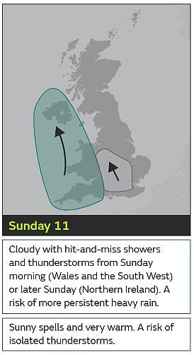
Deputy Chief Meteorologist, Dan Harris, said: ‘From Saturday night, into Sunday morning, there is an increasing chance of rain, showers and isolated thunderstorms moving northwards across the southwest of the UK.
‘As we continue through Sunday and into Monday, this will extend to other western parts of Great Britain and into Northern Ireland too.
‘On Monday itself, we could see some particularly vigorous thunderstorms developing, most likely in Wales and parts of southern England, whilst elsewhere during this whole period, dry, fine, and increasingly warm conditions are expected.
‘Should these thunderstorms develop, especially on Monday, there is potential for 25-35mm of rain to fall in an hour or so which may lead to some localised surface water flooding.
‘Hail, lightning, and isolated strong wind gusts would be additional hazards. Forecasting exactly where thunderstorms will form at this range is fraught with uncertainty, so please stay up to date with the Met Office forecast through the weekend, and any severe weather warnings which may be issued.’
Earlier this week, Simon Partridge, meteorologist for the forecaster, said while temperatures are ‘gradually warming up’ patches of frost are still expected in rural areas where there are clear skies.
Warmer temperatures are expected over the weekend, with southern England and south-east Wales forecast to enjoy highs of up to 24C on Saturday and 26C on Sunday.
The warmest areas may see some localised heavy showers on Sunday along with the ‘odd rumble of thunder’, Mr Partridge said.

The chance of showers persists into Tuesday across the far south but much of the UK will have another bright sunny day

The warmer weather is expected to remain throughout the weekend as temperatures will likely build again with highs of 26C to 27°C possible on Sunday and Monday

This comes after the UK saw its warmest start to May on record, with highs of 29.3C in Kew Gardens, south-west London, last Thursday
Of the chilly evenings and warmer days, he added: ‘It’s a classic sort of spring set-up really.
‘Going into summer, as we get more and more sunshine, the ground warms up more.
‘At the moment we haven’t had it (the sunshine) for long enough for the ground temperatures to be that warm, so then overnight, when we get those clear skies, the ground loses temperature pretty quick.’
During this time of year, it is common to see the ‘biggest range of temperatures’ between daytime highs and overnight lows, he added.
This comes after the UK saw its warmest start to May on record, with highs of 29.3C in Kew Gardens, south-west London, last Thursday.
The Environment Agency later warned that England is facing the risk of summer drought after the driest start to spring in 69 years has led to low reservoir levels, struggling crops and wildfires.
The National Fire Chiefs Council (NFCC) said fire and rescue services in England and Wales have responded to 464 wildfires so far this year, including in Dartmoor and Errwood Valley in Derbyshire, and have called on the Government to invest in fire services to address this ‘growing, year-round threat’.
The organisation warned that most wildfires are caused by human activity, including accidental and deliberate blazes, and that dry weather can worsen the damage caused by fires.

A person enjoys the warm weather in Regent’s Park, London
NFCC chairman Phil Garrigan said: ‘Wildfires are no longer a seasonal hazard – they are a growing, year-round threat to life, property and the environment, driven by the increasing impacts of climate change.
‘Fire and rescue services are having to balance their response to these growing numbers of extreme weather events while trying to maintain core emergency response.
‘This is not sustainable without proper support.
‘We are urging the Government to use the upcoming spending review to deliver long-term, sustained investment in fire and rescue.
He added: ‘We cannot afford for fire and rescue to be the forgotten emergency service.’
Leave a Reply